


Dearest everyone,
We hope you are well. Apologies for not being able to post sooner. A mix of poor WiFi and jam-packed hiking has meant writing up the days events hasn’t been as easy as we’d have hoped. We’re currently on day 90 can you believe (which shows just how out of date our blog has become) so we’ll try and get you all up to date while not missing any juicy bits. Since last we wrote we’ve been through the Shenandoah National Park, crossed 3 more state lines into Pennsylvania and set a new mileage record of 25.6 in one day. We are currently at mile 1143.1, over halfway!
However, to backtrack a little our tale continues at day 46 as we departed from Damascus. After a relaxful zero we headed back towards the trail, stopping off for ‘proper’ coffee at Mojoes Coffeehouse. It was, by far, the best coffee on the trail to date. The cawfee is by and large fairly poor, so this was a great treat, and coupled with an English muffin (a nice change from the American style biscuits/scones) and a homemade brownie it was fantastic fuel for the legs. But despite it, the first hill felt hard. The day off had made our legs a little sluggish and as we attempted the first 1,000 foot climb we took it a little slower than usual. The trail offered lots of interest as we crossed or followed the famed Creeper trail, which is a leisurely cycle route that most people get a ride up and cycle down.
We walked around 15 miles, taking us to mile 483.2, and stopped to camp at Lost Mountain shelter. It was bustling with hikers, as we have come to expect the first shelter out of town to be.
The next day turned out to be epic. We awoke with hopes of walking a record-breaking 23.2 mile day to Old Orchard shelter. Reports of poor weather in the area had abounded the night before, with rain expected between 7am and noon. Despite rising after 8am we were lucky in that the rain had barely materialised and the tent could be packed away easily. We snacked on granola bars, said goodbye to those left in the shelter and started on the 1830ft climb of White Top mountain. Trademark, a fellow thru-hiker we had met at the shelter the night before, left just after us and soon caught us up. A wise-cracking New Jersey boy, who proudly informed us that he can cycle into Manhattan in just 32 minutes and takes daily selfies of his beard.
The climb was long and not overly steep, but early in the morning it was hard to hit our 2mph par speed and already our 23.2 mile goal was looking a little suspect, but thankfully no more rain. Well, not until we had reached the most exposed part of the trail for that day, at Beach Mountain road, where we enjoyed a liberal spraying from above. A quick pause among the spruce saw pack covers and jackets adorned and the climb continued.
When we reached the summit the smell of wet scorched earth and grass filled the air across the vast bald, which very recently had been subject to a large scale controlled burn. The wind began to howl across the flat surface, hurling the rain which now poured, sideways across the landscape and pummeling our faces and bodies like frozen bullets. We were forced to lean into the wind to stabilise ourselves, which just meant a larger surface area was exposed to the icy daggers. We braced ourselves and marched as fast as possible to the relative safety of the tree line, nearly a half mile away. Once under cover and calm restored we pushed on. We reached the highest point of our walk, which was a mountain spring, and stopped to replenish water stocks. As I reached to fill the platypus container, I paused, hearing what I thought was the heavy wing beating of a grouse and the odd chest pounding noise it makes at such a low frequency it has caused some people to think it was inside their own head, some sort of rapidly accelerating heartbeat or their blood pressure.Apparently its something to do with mating or a show of strength that operates at a subwoofer level.
As I carried on filling, my head was drawn upwards to the source of the sound, causing me to spill some.of the icy cool water on my fingers. Something didn’t sound right. The grouse was morphing into sheets of metal being manipulated. Fran guessed they were building a shelter nearby which seemed a stretch but that is exactly what it sounded like. Then it hit me. ‘Fran’, I said, ‘thats not a grouse, that’s thunder’. Trademark, who we’d been leap frogging all morning, rounded the corner behind us. ‘Err, does anyone not like the sound of that?’, he said a little flustered. And that’s when it happened. It was as though someone had flicked a light switch. In an instant it was gloomy, then suddenly illuminated in every direction with the force of a thousand flash bulbs at once, followed in a nanosecond by a terrifying ‘CCCRRRAAAAACCCKKKK!!!!’. Lightning. And it was extremely close. The heavens opened and within seconds you could have gone trout fishing within the puddles forming around us. Trademark asked if he could stick with us and we hastily agreed as I packed the water filtration back into my pack and attached the pack cover, desperately trying not to let the downpour into my pack. I told the others to get moving as I finished up, the important thing now, to get to lower ground. Pack on, clips clipped, I started down the trail after them. Already drenched I didn’t even try to avoid the puddles. Marching straight through in my hasty pursuit. Lightning strikes continued to burst the blackness followed by the growl of thunder while the rain turned to hail so hard it felt like it could cut you. The others were moving through the gears so fast they were already nowhere in sight. Realising this, hey waited for me, and by the time I.caught them the lightning was thankfully moving away from us. We covered the 1.5 miles to the road at Elk Garden in exceptionally quick time and were out of the rain. We were safe. We even had a little trail magic, a red cooler with much needed sugary treats. Our friend Blue Jay was with with another hiker, Dallas, taking shelter under the porch of the car park restroom. Needless to say, we were happy and relieved to see friendly faces after our ordeal. Lightning has been known to strike (and kill!) hikers and atop a mountain is the last place you want to be! We moved on quickly to keep warm, heading uphill towards Thomas Knob shelter, a further 4.3 miles away. The walk was long amd exposed and whilst the hail and lightning had subsided, the rain and wind continued their relentless campaign. We reached the shelter but it was already nearing maximum occupancy, and tenting didn’t look ideal in the rocky terrain. We decided to push on another 5.1 to Wise shelter, which some south bounders had said was practically empty when they passed. The extra miles meant we would cross the 500 mile marker, and traverse the beautiful and famed Grayson Highlands, where wild ponies roam. In near white-out conditions we navigated over rocky boulders and exposed moors, not expecting to see any ponies as we ourselves were blinkered to all but the trail by our rain jackets. But to our complete surprise as we rounded a corner, framed by our hoods were two wild ponies grazing by a rocky outcrop. No time to chat, we exchanged equine pleasantries and powered on. Fingers numb, shoes and clothes drenched, but with our spirits high at nearly competing 17.3 miles in horrific conditions and crossing the 500 mile marker, we reached the shelter only to see 20 people gathered around it! Thankfully it was a school group who planned on tenting and with the worst of the weather blown away, and an excellent forecast for 10pm onwards, we found plenty of space in the shelter, changed our clothes, ate, climbed into our sleeping bags and marvelled at the remarkable day that was.
In the morning we rose and set off, unsure exactly how far we might walk. After just 3 miles due to some hidden blazes and lack of attention we took an unexpected detour up a separate trail called the Scales track. Whoops. A mile round trip later we’re back to where we went awry and heading toward Old Orchard Shelter. There were lots of day hikers around and after a long morning we stopped for lunch, chatting with some section hikers in the shelter. We walked on through the afternoon, passing Hurricane Mountain shelter where we met Mambo, Pip, Dfi and Haas who had heard from a day hiker that there was a diner just 2 miles off trail from Dickey Gap, in an easily hitchable area. We joined the mission to reach the diner, filling our thoughts with burgers and milkshakes. From Dickey Gap we stood perplexed. No signs and the people we asked said it had shut down the year before. It was gone 6pm and the only options were to wild camp or push on 4.5 miles to Trimpi shelter or a campsite shortly before. Tired but with few wild camping spots available, we pushed on, arriving at the shelter just before 8pm. Tired! We’d covered 20 miles in total and our feet felt it. We were quick to bed that night.
The next day most people in the camp were up early and by the time we emerged from the tent the final stragglers were preparing to leave and we were left to pack our stuff up alone. The terrain looked fairly easy going for the morning and just 10.6 miles away, and via a gazebo full of trail magic, was Partnership shelter, one of the most popular on the trail.

The shelter fits a whopping 16 people and has a solar shower. The Mount Rogers Visitor Centre is just a few yards away, and the town of Marion is easily accessible from the nearby road. Oh, and importantly, pizza restaurants will deliver to the shelter! Others who arrived there at the same time ordered pizza, but we were thinking instead of heading to the next shelter and getting our resupply at the convenience store in Atkins rather than in Marion. We arrived at the next shelter at 6pm, and as we were feeling fairly spritely still, decided in a rather radical decision to walk another 4.5 miles to Atkins. We did what we now refer to as ‘doing an Atkins’ which means pushing a bigger mile day to get to town late and leave first thing in the morning without getting sucked into the town vortex, but still reaping all the benefits. On our way we passed some fantastic trail magic in an old village school house.

Not only did the magic feature the usual sodas and chocolate but a vast selection of first aid, general hiker supplies and fresh fruit. It was fantastic. We thoroughly enjoyed the walk down into Atkins. Plants were starting to bloom, all shades of greens were present in the lush woods, and blossom added sweet scents to the forest air. Virginia felt alive. We saw an otter as we crossed some wetlands and streams, crossed a rail road, and then arrived just as the sun was setting, around 8.15pm. We’d breezed through 22.2 miles. The Barn restaurant we’d heard about had just shut sadly, but we took a room at the Relax Inn before heading to the gas station to resupply. We were pleasantly surprised to find we could get enough hiker-suitable food for the next few days and after some pleasant chats with random gas station truckers, we headed back to our slightly smelly motel room to order pizza. We packed up our supplies so we were ready to head out at 9am the next day.
Thus day 49 began, and after tearing ourselves away from watching Indiana Jones in the motel room, the first stop was The Barn restaurant for breakfast. A plateful of eggs and sausage later, we staggered across the Interstate 81 underpass to start our hike. Both of us feeling a little too full for walking. After an exciting sighting of a wild turkey and the happy realisation that by being a little after mile 546 we were a quarter of the way through the AT, we had a moment of worry as thunder and lighting struck. We double-timed it, hoping to find shelter, but thankfully the storm was only brief. We crossed some meadows, passed some cows, hopped over fence stiles and saw our first deer! After an unexpectedly hard climb up Brushey we decided to pull in for the night a Knot Maul Branch shelter, after 13.9 miles. We were at mile 556.6 and had only been at the shelter 10 minutes before it started to rain, making our decision to stop even more satisfying. Seven of us slept there, a friendly bunch including two Germans, two Americans and a Brit/New Zealander.
The morning of day 51 began with one of our shelter fellows offering us some hot cider. In the USA ‘cider’ is non-alcoholic unless called ‘hard cider’. So no, we weren’t hitting the booze that early! We headed off at 9am and after 5 miles started a massive climb of 2,000 feet to Chestnut Knob shelter. The shelter is a fully enclosed concrete block structure, so we dived in for lunch, luckily choosing just the right time as it rained for the next half hour. We met another thru-hiker called Caveman and discussed the possibility of heading to Fort Bastian that evening, home of TruBrit, an ex-pat ex-SAS soldier now in the process of setting up an outdoor education centre and offering hikers a fun night off the trail camping in his forest. The miles that afternoon took longer than expected however, as the ridgeline we’d seen detailed in our guide turned out to be a form of rocky torture. The last 5 miles however, were easy undulating terrain and we raced to meet TruBrit. We set a new record for the day, hiking 23.9 miles. We jumped into TruBrits landrover and were driven over higgledy piggledy backroads to the heart of his 35 acres.

Despite arriving late, the evening was only just beginning. It was a fellow hiker’s birthday so the ‘party tent’, complete with surround sound, was filled with beer and whiskey. We sang along to Paul Simon’s Graceland, toasted to good health and chatted into the early hours with new friends.
Following a camp breakfast at 7.30am we got a lift back to trail the for day 52. We passed turn offs for towns called Bland and Bastian, and a sign for the Trail Boss trail!

We traversed a long ridge line with few if not no water sources for a long while, aiming for Jenny Knob shelter. We made it there around 7.40pm with time to cook and get water just before we lost the light. A long hard day, but a good solid 19 miles. We met Big Gulp and Pretty Bird, Pumba, Kalpacca and a load of others.
We were the last out the next morning, which in the long run doesn’t mean much but at the time makes you feel a little lazy. It was a fun walk with a suspension bridge, half a packet of doritos and a can of beer for trail magic, and a picturesque riverside lunch spot.

But the long mile days previous were taking their toll and we struggled through the 1,300 foot climb after Wapiti shelter. We had to carry an extra litre of water as there were no more sources for 10 miles. We spent the night at Big Horse Gap, our first ever experience of wild camping alone. We had a small fire and enjoyed the solitude.

There were some rather interesting noises in the night. In particular a sneezing growl from a large-sounding animal that was probably a bear…and that was the end of day 53. We were at mile 619.3 and had covered another 19.8 that day. The following day we were to head to Pearisburg, but more on that next time 🙂
Bear hugs,
H & F xxx


Just need to find the key…


Dearest everyone,
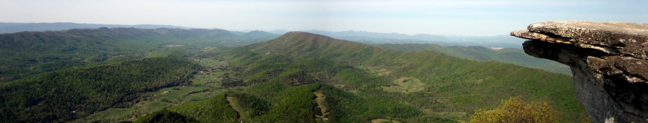
Fran on the blower this time. We are currently in Daleville, Virginia, having walked 724 northbound miles. We are spending the night in the local hiker-friendly motel having started hiking at 5.30am this morning to catch the sunrise at the famous McAfee Knob, a picture of which has been Harry’s PC wallpaper for the past 9 months whilst we planned for the trip! It’s also pictured on this blog’s header image. A special day and 18 trail miles complete by 2pm, which is definitely a record! Hope all is well at home, here’s the next chapter of The Appalachian Express…
We awoke at Clyde Smith Shelter on day 38 to frozen shoes and a thin layer of snow calmly covering the world around the shelter. The tarps ingeniously rigged by Super Scout had held the winds at bay overnight. As the cold air of early morning began to thaw we dared to hope for good views while crossing Roan Mountain.
The morning was to comprise a climb of 2,160 feet. Thankfully the long switchbacks on the trail made the climb enjoyable, but as we crossed Ash Gap and climbed the final 800 feet, the cold of the day before was all too evident in the cascades of ice that now covered the trail. We skidded and clawed our way up each section, each turn bringing a new icy challenge, until we reached the high bluff and knob. Having walked 8 miles that morning we then stopped for lunch at the picnic area near the parking lot, lamenting the fact the restrooms (US lingo now!) were locked. Having successfully navigated the treacherous ice path before, Harry was irked to find some ice sneakily hidden in the shadows of the parking lot and took a tumble by the guard’s cabin, thankfully his pack took the brunt of the fall and no damage was done. Darn parking lots!
After Roan Mountain, we descended through yet more treacherous ice, and missed a turning or two before we traversed three grassy balds. The balds were glorious. We enjoyed the bright sun and cool air and even a bit of trail magic, consisting of brownies and sodas. That certainly helped us well on our way.

We passed Stan Murray Shelter finally making our way to Overmountain Shelter, a converted barn. The red barn is iconic on the trail, with views over a far-reaching valley and enough space to fit 20 hikers. Alas, that evening the cold winds ripped through the barn, up through the floorboards and forced hikers into their tents, inside the barn!

The next day afforded more beautiful views as we crossed Little Hump and Hump Mountain. For the last couple of weeks we had been crossing back and forth the border between North Carolina and Tennessee, and now, descending from 5,587 to 2,900 at mile 389.3 we crossed Doll Flats where we finally left North Carolina, to stay in Tennessee until we reached Damascus, Virginia.
After a total of 8.7 miles that day we hit a road crossing where we detoured to stay the night at Mountain Harbour, a B&B and hostel famed for having the best breakfast on the trail. We had heard great things and after rain, snow and a gruelling few days we were eager for some R&R. Having rung ahead the day before we had booked the Jefferson Suite, and sweet it was. This was the money maker for the B&B, a massive room with fireplace, large four-poster bed, jacuzzi, and furnished exquisitely in a homely chic style. I could have lived there quite happily. The bed had steps up to it, or, with a running jump you could plough head first into the mints nestled by the pillows. You could not ask for more. We dined at the BBQ joint in town, Harry demolished the Holy Cow (!) burger, a gastronomic challenge worthy of Man VS Food. We resupplied at the local store, which was a stretch as the offering was modest, and returned to Mountain Harbour to enjoy the room. Having showered, bathed and then showered again in the morning, we must have been the cleanest we’ve been in a long while! The jacuzzi soothed our achey feet and we climbed into bed where we slumbered peacefully until the morn. Thereupon, at 8am, breakfast was laid out. It lived up to every possible expectation and more. Homemade sourdough bread, baked ham, green bean and cheese flan, apple tart, muffins, an egg pizza thing, home fries, waffles, coffee and juice. So tasty and such a cosy family atmosphere.

From there we left around 11.30am, still digesting, to head up into the mountains. We met a new hiker that morning, called Indiana, who, with ultralight pack, lean long legs and flowing locks, looks made for hiking. He quickly sped past and we cranked up the speed until we were once again striding along at our usual pace. Quite by surprise, an hour or so later we espied Early Bird and called out to her ahead. It was great to see her again, having been out of touch since Erwin. We caught up with Junko and Minty and then walked and talked for the remaining 8 miles of the morning. We reached Mountaineer Shelter to pause for lunch, quoffing the final PBR (beer) left over from the night at Mountain Harbour. We chatted with Captain D and PC6 who were settling in there, much to our enjoyment (we later saw them at Damascus too). Leafing through the shelter journal we saw Stretch and Fresh had left a note, urging us to join them in Damascus on Sunday for an Easter feast. We were at once elated and deflated. It would have given us great pleasure to do so, but it was Friday and we were too many miles away. This was day 40 and we didn’t reach Damascus until day 44. Happily however, we had walked nealy 10 miles in 3 1/4 hours, we felt like we were flying. We ploughed on, beer racing through our system, hoping to continue the high speed. We ended up walking 17.2 that day and wild camping on the side of the trail, with a small fire and pasta dinner we settled down for the night. Even before lights were out we could see a whole flock of rabbits running around the undergrowth, a new, if not uncommon, animal for our wildlife watch. We went to sleep, looking forward to the next day where we would cross paths with a town called Hampton!

In the morning we had only 8 miles to the junction to Hampton. It was a surprisingly long-feeling 8 miles. We met just one person along the way, Jeff, who heartily recommended staying at Black Bear Resort, and as Junko and Early Bird were headed there, we followed suit. We took a small cabin and stocked up on snacks from the shop. Soon after, Bob, the co-owner, drove us into town. Knowing we were eager to compare this Hampton with that of South West London, he wonderfully and kindly offered us a 10-cent tour. We saw Watauga Lake and the dam, the largest earthen dam in the States. He took us the length of the town via an old-school grocery store, finally stopping at MacDonalds where we bought dinner and donated a dollar to the local boy scout selling coupons outside. It’s a small town, and apparently in a poor area. Over this and the next few days we were to hear about how rife meth labs are in this and nearby towns. Quite surprising! Anyhow, we returned to Black Bear Resort, at mile 417, and watched Young Guns (‘Regulators mount up!’). The 80s soundtrack was cracking.
We left at 9am the next morning, walking past Laurel waterfalls, which were stunning, and up a steep climb to pond flats. Straight back down, we found ourselves by the lake and dam we’d seen the day before, where we stopped for lunch. 
The sun was shining and we enjoyed the walk round the lake and over the dam itself. By now the day was starting to feel long and while others stopped by the lake for the evening we pushed on to the Vandeventer shelter, at mile 434.5. We watched avidly for a spring, listed in the guide as being nearly two miles earlier. Having passed what appeared to be a mere murky puddle, it transpired that it was indeed the spring, and having missed it we had no more water sources until the shelter. Fine you would assume, but at this shelter the water source was 0.4 miles away and down an insanely steep ravine. With the sun rapidly falling we set off down the ravine and with each step were bewildered by how far and how steeply it could unfold. Water in hand we slowly clambered back up to the shelter to capture the final moments and fiercely bright colours of the sunset. As night fell we packed up our dinner things and enjoyed the clear, vast views from behind the shelter of the valley and towns below. Twinkling lights of the homes below offered a beautiful view with a human touch, which we shared with Plan B and Movin’ On, two new hiker pals at the shelter.

The next day was Easter Monday and we rose expecting to enjoy a relatively ‘flat’ ridgeline all the way to Abingdon Gap Shelter, a whopping 22.7 miles down the trail. It was harder than we thought, calling on inner reserves. It’s surprising how many grave stones and monuments you can come across along the trail. That day we came across Nick Grindstaff’s monument, which rather morosely read ‘He lived alone, died alone, and suffered alone’. Food for thought. We pushed on and reached mile 457.2, a new personal best of 22.7 in one day, and leaving just 10 miles to Damascus, the next town that the trail actually travels through. We’d read about people hiking a Damascuthon, which is walking 33 or 50 miles or something crazy, in just 24 hours. Not sure really, seems to be different for each person, but we were happy with 22.7 to reach Abingdon Shelter. We were the only two to sleep in the shelter, perhaps everyone else, some 10-15 tents, knew the mice were on something! They were pretty hyper all night, a proper disco on the metal roof and sliding all over the place. It was the first time we’d actually seen mice, and they were brazen. Thankfully they left our packs alone and I slept sound. Harry, however, awakened, repeatedly through the night, woke early. As I dozed on, he fell back asleep and cricked his neck. Painful! We both finally arose at a respectable 8.30 to find everyone else had gone.
It was only 10.4 miles to the middle of Damascus and everyone set off early to make the most of the day. As we walked we used patchy reception to ring ahead to find a room. With the Hikers Inn fully booked they recommended Ruby’s Rest and after a couple of calls we had a private room booked. Jeff at Ruby’s Rest sounded so friendly on the phone and we quickened our step, eager to meet him. Via lunch at Dairy King we made our way up a residential street to Jeff’s place. The room wasn’t quite ready but Jeff generously thrust a beer in our hands and as the rain started, sat us down in his car port. We felt so relaxed, and strangely American at that moment. From then on we had the most fantastic day and a half.

The room at Ruby’s Rest was a small cottage in the garden of Jeff and Nicky’s house, and had an ensuite bathroom and cosy double bed and bunkbeds for two more if needed. The wall to wall books, beautiful furnishings, coffee maker, DVD selection and beer-stocked fridge made us feel instantly at home. But chores need to be done. First stop,the pharmacy. My knee was hurting, and Harry’s ankle too, so we stocked up on supports, sun cream (factor 50 this time!), and vitamins before moving on to the outfitter. We needed to replace our leaking sawyer filter bag. The guys were out of stock but had a platypus that could potentially fit, and as it was missing a cap was given to us for free. Amazing! We bought a couple of things, and as we enjoyed the company at Mount Rogers Outfitters, we chatted with a guy called Doug. He generously offered to drive us up to Food City, and we made instant friends. We listened to Old Crow Medicine Show, chatted and horned moonshine on our way to the store. Minutes later we were back at the Rest contemplating dinner. Following some ramshackle but fun Mexican food, we joined fellow hikers at the Blue Blaze Cafe for some drinks. Red Dog, Red Beard, Raffiki, Walking Stick and pals were there. We perhaps had one too many as the next morning we promptly decided to zero. My knee was hurting, as was Harry’s neck still, and the cottage was too nice to leave! The extra day meant we met up with Junko and Early Bird again, and got some decent sleep and movie-watching done. I still think of that lovely cottage and great people, it was a fabulous stay.
More next time 🙂
Harry and Fran xxxx
Dearest everyone! We are writing to you from Pearisburg, Virginia at mile marker 631.3 after an epic stint since Damascus pushing out just under 20 miles a day for 8 days! So much progress in a short time frame has put us in a really good position time-wise in the long run and means we can fall back a little bit on the mileage which is a relief as it really takes it out of you doing consecutive big mile days. All continues to be wild, endlessly unpredictable and breathtaking and we are in fine spirits and our feet are very greatful for a day off the trail. Hope everyone is well, sorry the blog is a bit out of date! We’re both tapping away in the dorm room of a Holiday Motel here in Pearisburg to bring you guys up to date…
Leaving town is usually a challenge for a variety of reasons. Packs are newly laden with resupply, heads reminded of the pleasures of pillows, bellies gorged on big eats and almost inevitably a climb back up into the mountains with towns tending to reside in the valleys below. Adding the nearly 2 full days off trail to the mix, leaving Hot Springs was hard. The climb out was steep and rocky though offered excellent views over the town as we rose back up into the hills and on to Spring Mountain Shelter, 10 miles away.
Towns have a concertina-like compression effect with hikers previously a day or two apart now overlapping by a day or a few hours with most of the hubbub centered around the hostels, bars and outfitters. The big positives of this are meeting lots of new people and the chance to catch up with friends that you haven’t seen for a while. The down side is that the first shelter and surrounding area out of a town is usually rammed and Spring Mtn. was no different, forcing us to hike on up the hill and pitch well away from the shelter and its ammenities.
The bear bag we hung that night was worthy of an award and a photo of it could easily have gone in next year’s hand book. The branch we chose was a perfect girth and height from the ground and was a perfect 90 degrees from the tree. The cord was flung first time at a perfect distance away from the tree and it was tied off against a suitably sturdy adjacent tree. We stood and marvelled at how far we’d come since our first foray into bagging and headed to bed.
At 8am the next morning we awoke to some newly made musician friends, Rafiki and Walking Stick playing the Native American flute, a stirring and haunting melody melding with birdsong and wafting through the still cool morning air. A truly lovely way to start the day.
It was at this point that Early Bird and Junco, who had arrived late to camp the night before due to the acquisition of Minty and their final attempts to ask the people of Hot Springs if anyone knew who he belonged to, informed us through the wall of the tent that in the darkness they had spotted our bear bag and opted to hang over the same branch but the additional weight had snapped the entire girthy limb clean off sending our food bags plummiting at speed to the forest floor below. Typical. Even more typical was that when we had resupplied in the Dollar General we had ummed and arred over some small pots of fruit in syrup that had suspiciously sticky lids that we haven’t carried before or since and opted to go nuts and take them out on the trail. Of course they reacted badly to the sudden and immediate introduction of the ground and promptly coated the rest of our stuff in delicious mandarin juice. Ohh you have to laugh, and after a few zip lock bag exchanges and a scrub out we were back on track!
We had heard from a girl we met at Standing Bear Farm about a woman who had opened a small store inside an old gas station and now offered a short term resupply option and this was the day we were to be in the area. Sure enough there was ‘Mom’s Store’ just off the trail complete with hastily spray painted signage, cracked windows and a thin streak of smoke emerging from no discernable chimney.

From the outside we thought we were about to walk into the setting of a horror movie but as soon as we got inside were greeted warmly by a woman whose family had used to run the gas station back in the 50s and where they’d also had a secret honky tonk out back, a restaurant and generally been the life and soul of the small community. The now dilapidated and ramshackle building was littered with junk, old cigarette advertising boards and was barely standing but oozed history and she had us enthralled with stories of the glory days and the various generations of the family that had been a part of its history. We scooped up some snacks and a 6 pack and headed on up the path.

No sooner had we got back in the woods than we bumped into trail magic provided by Shadow and Country Mouse who are former AT thru-hikers and had lots of great tips and interesting things to say about what’s ahead and managed to convey it all without sounding like the oft prevelant M.A.A.M.s (middle aged advice machines) who can sometime get more than a little grating when they insist on telling you that your tent is about to fall off or you’re starting a fire/ tying a knot/ wiping your bum all wrong.
Bellies full and spirits high we headed to the big highlight of the day, the exposed ridgeline of Firescald Knob. Despite a long climb we passed no other hikers and with the sun high in the sky on a cloud free day we walked on for the promise of spectacular views from the high, exposed vantage.
We were therefore a little surprised at the summit that sat on the rock that marks the pinnacle was a small fat and disgruntled looking middle aged man talking loudly on speakerphone. You couldn’t make it up! His poles splayed across the trail and his ample frame made it hard to find a vantage that encorporated the full landscape and even with a view the peace of the wilds was somewhat punctured by the rambling, pointless conversation that was unfurling in stereo atop one of the most remote places you could imagine. Fran and I looked at each other and shook our heads in disbelief half laughing and motioned to each other to move on. For obvious reasons playing music out loud on the trail, talking on phones let alone speaker phone and generally stuff that counteracts a wilderness experience is frowned on and truly it was dreadfully intrusive but we chuckled it off and luckily found a pretty decent look out spot a little further along the ridge.

We navigated the hands-on rocky climb down the knife-edge to Jenny Cabin where a trail buddy named Sole Power had quite brilliantly organised a camp fire story time in the hope that every Wednesday, whichever camp fire you happen to be at and with whomever, you can each share a story and for that time everyone will listen. Our friend Bluejay told of an eccentric woman she had used to run errands for and was very fond of and related it to legacies and the passing on of knowledge and friendship. Three Thumbs talked of his time in the Vietnam war aboard an aircraft carrier and an extraordinary twist of fate that he saw from the bridge as a pilot ejected from a plane and whose parachute got stuck in the netting at the very front of the ship on the way down and he just swung side to side until the others pulled him up. Many spoke and all listened and it was a genuinely moving and spiritual experience sharing and bonding in the moonlight by the crackle and fizz of a well stocked camp fire.
We slept soundly in our trusty tent then set out after oatmeal and coffee on the 15 miles to Hogback Ridge Shelter. In the middle of the woods quite out of nowhere we passed a gravesite for the Shelton family that was adorned with plastic flowers and American flags. It wasn’t until we bumped into the trail maintainer Lord Willin’ and his wife candy who were doing trail magic at Flint Mountain shelter that we found out the story of the gravesite. During the civil war, two brothers from North Carolina had gone to fight for the North and survived the brutal, bloody conflict only to be murdered by their kin on their return south. The gravesite was created by some of the family who objected to the murders and the family still feuds over the rift to this day. Crazy.

The rest of the day was filled with waterfalls and cascades galore and when we reached the shelter someone had left a sign saying that from 8.30am the following morning there would be scrambled eggs, hash browns, fresh muffins and drinks served for hikers at the gap 3 miles on from the shelter! There was feverish excitement and as we played cards and pottered about that evening we couldn’t wait for the prospect of a hot cooked breakfast right on the trail.
We speeded at record pace down to the gap and sure enough there was Quiet Paul, a former thru-hiker who just comes out for 10 days a year to give back to the community which gave him so much on his hike. It’s easy to see where this desire comes from, the generosity is often awe-inspiring and makes you yearn to offer something in return.
Our tums full and our deepest gratitude offered to Paul we set out for Big Bald (323.9) at over 5,500ft. The views were jaw dropping and a man on a day hike played the penny whistle as we lay on the grass staring at the swirling-blue sky.

Three Thumbs was at the summit with us and we followed his tracks down the bluffs to complete a 20.7 mile day to No Business Knob Shelter after nearly 12 hours on the go! Big day. We pushed hard to only leave 6 miles to Erwin and the trail-reknowned Uncle Johnny’s Hostel the next day.
We made the climb down in good time and checked in at the hostel. The porch was busy with hikers chatting and drinking to the sound of a rock radio station that played 24 hours a day through outdoor speakers. This seemed like the place to be on a hot sunny day. Unfortunately all the cabins were taken so we tented in the yard.

The washroom was a seperate wooden building with hot showers and laundry and had everything we needed. News articles littered the walls reflecting the glory days of the hostel and the building of a designated cycle path in to town built especially for the hostel.
The place in essence was actually being bossed by a gruff new yorker with a heart of gold called Sarge. A portly man with a long black goatee and a sleeveless t-shirt and a single tooth who informed us that he has a knife he calls the ‘hiker tamer’ that he’s only had to use the once. “Why’d you fink dey call me Sarge” he managed to squeeze out around his single denture followed by a knowing wink intended to demonstrate his authority about the place. He was actually a lovely bloke and gave us a run into town to get our shopping done and grab some Mexican food.
We had planned to head out the following morning and took down our tent but just as we were about to leave Early Bird, Junco and Minty arrived and the lure of the sunshine, our pals we hadn’t seen for a few days and the comfort of Uncle Johnny’s porch with 24 hour rock classics was too much and we decided to pull a zero and just take it all in and relax. We have to remind ourselves sometimes that we’re the boss out here and make our own timetable. Though we’re ever aware of our 6 month visa deadline and there is still a hell of way to go!

Fully refreshed and itching to get on the trail again we said goodbye to Uncle Johnny’s and to Erwin, Tennessee and with the threat of thunder in the weather report we set out for Cherry Gap shelter at marker 359.0. The weather held but the climbs were brutal. The highest peak, Unaka Mountain rewarded our efforts however with a sprawling glade of miniature spruce trees that made it look like the place where they grow all the world’s Christmas trees in secret before sending them out to nestle in cozy livingrooms the world over. A perfectly timed cup of coffee furnished by Brother Tom at Indian Grave Gap who is setting up a new Catholic church in Erwin to rival the rumoured 66 Freewill Baptist churches (town pop. 4,586) saw us through the miles and we nestled in at Cherry Gap shelter with Red Dog, Flat, Flipper, Dot Com and Queen as there was a high threat of rain in the night.
The rain inevitably came in the night and we were extremely grateful not to have tented. Without having to pack up a sopping wet tent we got away in good time and, spotting a break in the rain, set out to summit the mighty Roan Mountain and stay at the highest shelter on the whole AT, the fully enclosed Roan High Knob shelter at 376.0, 17 miles away.
After just a couple of hours on the trail the weather turned nasty. Super nasty. We were drenched within minutes of a downpour and the rain that continued to fall was on the verge of freezing in the air as it fell. The wind ripped and tore through the trees taking the temperature of our bodies to dangerously low levels. We did our best to reconfigure our attire to better keep out the vicious conditions but could see that it was rapidly becoming a very bad situation and a losing battle. As ever, walking was our best and only weapon and we pushed with everything we had just to cover the 9.1 to the next shelter, Clyde Smith.
When we arrived the small shelter was already heaving with people desperately stripping off their dangerous wet clothing and replacing it with anything dry to prevent the rapidly dropping temperature causing serious problems. It was suddenly a very real survival situation on a day that had started without any thought we’d be forced off the trail by the weather.
We stripped, toweled, reclothed and got into our sleeping bags. My body shook with cold and it looked at times like I wouldn’t be able to get warm at all but I am eternally greatful for the power of my sleeping bag. We got inside our bags, battoned the hatches and decided to wait it out. Whilst we felt like the very gates of the abyss were opening beneath us, a trio of youngsters, Rainpants, Pyro and Mio set out to complete a 36 mile day to the famous Mountain Harbour bed and breakfast. We couldn’t believe what they were doing. As the temperatures plummeted below freezing and the rain indeed turned to a howling blizzard of snow they set out to summit and descend Roan Mountain.
Remaining in the shelter were a father and son, Opie and Super Scout, us and 3 others, Raven, Sparky and Murphy. We were going nowhere even though it was only 1pm in the afternoon.
As the time in the shelter started to drag and the wind continued to howl we watched the snow fall from our bags and Opie offered to read from a book of Jack London short stories he had and elected to read “A Piece of Steak” (which I can highly recommend reading).
As we snuggled in our bags now warmed and relieved, Opie in his silvery tones told us the story of a seasoned old boxer using his wisdom in a match against a much younger glory hungry fighter. The tale unfolded like a parable that immediately drew comparison to the lads who had set out for glory whilst we called it and settled in early. We didn’t see those guys for a while but can assure you that they are all alive and well and though it got hairy made it almost all the way through their challenge though had to cut it short by a few miles.
Warm in our bags and soothed by the tale we fell to sleep, happy to be just exactly right there.
More next time…
Bear hugs, H and F xxx


